Laos
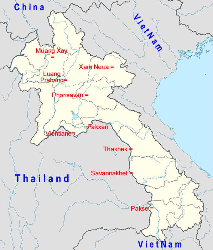
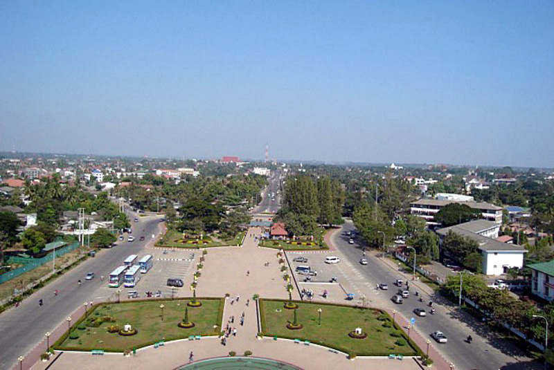
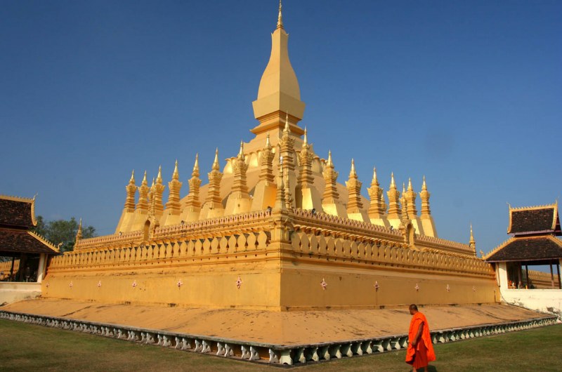 Vientiane
Vientiane (Laotiaans: ວຽງຈັນ Wieng Chan, IPA: [wiəŋ-ʧan]), is de hoofdstad van de republiek Laos en ligt in de Prefectuur Vientiane (Kamphaeng Nakhon Wieng Chan). De stad heeft ongeveer 400.000 inwoners. De stad ligt aan de noordelijke oever in een bocht van de Mekong rivier. De naam Wieng Chan komt van Wieng (stad of plaats met muren) en Chan (de Lao-vervorming van het Sanskriet woord Chandana dat sandelhout betekent). De Fransen romaniseerden de spelling tot Vientiane. Vientiane wordt samen met Phnom-Penh in Cambodja en Saigon (Ho Chi Minhstad) in Vietnam beschouwd als de 3 klassieke Franse indochinese steden. Deze worden geassocieerd met de klassieke koloniale Europese architectuur.
 Pakse
Pakse
Pakse or Pakxe (French Paksé; Laotian ປາກເຊ [pȁːk séː] "Mouth of the river Se") is the capital and most populous city in the southern province of Champasak, making it the third most populous city in Laos. It has a population of about 87,000,[1] situated at the confluence of the Xe Don and Mekong Rivers. It also served as the capital of the Kingdom of Champasak until it was unified with the rest of Laos in 1946.
 Savannakhet
Savannakhet or Kaysone Phomvihane (Lao:) (population 120,000) is a city in western Laos and the capital of the Savannakhet Province, previously known as Khanthabouli (). This is the second-largest city in Laos, after Vientiane. The city is birthtown of Kaysone Phomvihane, former president of Laos, and was named after him in 2005. Although the old French colonial quarter of the town, along the Mekong River-front, is depressed and crumbling, the town's proximity to Thailand's booming economy has brought about new commercial development in the northern part of the town, near both the river crossing and the bus terminal.
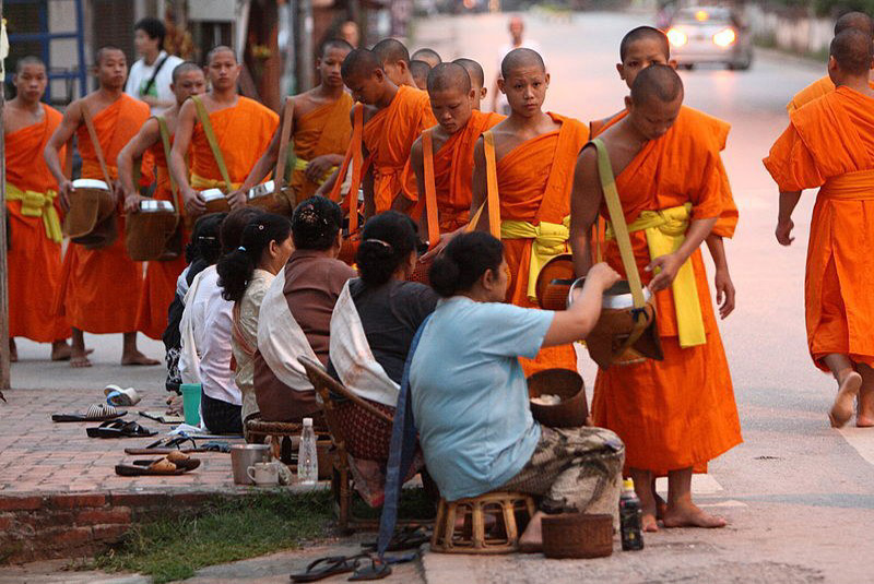 Luang Prabang
Luang Prabang, or Louangphrabang (Lao:, literally: "Royal Buddha Image (in the Dispelling Fear mudra)," pronounced [lǔaŋ pʰra.bàːŋ]), is a city located in north central Laos, at the confluence of the Nam Khan river and Mekong River about 300 km north of Vientiane. It is the capital of Luang Prabang Province. The population of the city is about 50,000.[1] The city was formerly the capital of a kingdom of the same name. It had also been known by the ancient name of Chiang Thong.[2] Until the communist takeover in 1975, it was the royal capital and seat of government of the Kingdom of Laos. It is a UNESCO World Heritage Site.
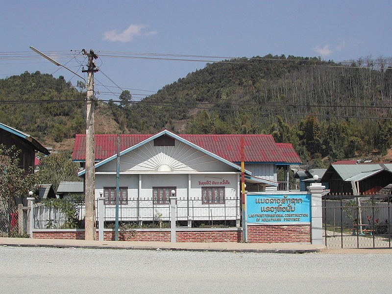 Xam Neua
Xam Neua (ຊຳເໜືອ [sám nɨ̌ə]; sometimes transcribed as Sam Neua or Samneua; literally "northern swamp") is the capital city of Houaphan Province, Laos, located in the northeast of the country. Xam Neua is one of the country's least visited provincial capitals by Western tourists.Residents are mostly Lao, Vietnamese and Hmong, along with some Tai Dam, Tai Daeng and Tai Lu. The predominant language is Lao with minorities of Vietnamese and Hmong. French is still spoken by a minority of people as a legacy of the French colonial era and is learnt by younger populations and used in public works and government.
 Phonsavan
Phonsavan (Lao:) (population 37,507)[1] is the new capital of Xieng Khouang Province, Laos. The name stands for "hills of paradise". Phonsavan is the provincial capital of Xieng Khouang province. The countryside is soon dominated by green hills and pine forests. Villages consist of colourful wooden houses. Cattle raising is one of the main agricultural activities and Hmong cowboys with brown and violet cowboy hats are a common sight. During Hmong New Year there are even bullfights in the city. Phonsavan was built in the late 1970s and replaced the old Xieng Khoung (today: Muang Khoun) which had been destroyed during the Second Indochina War. Phonsavan's most famous attraction is the nearby Plain of Jars, which has been nominated for UNESCO World Heritage status.[2] The main economic activity in Phonsavan is based on government administration, mining companies from China and Australia, tourism and the work of NGOs related to UXO clearance.
 Thakhek
Thakhek (Lao language:) is a town in south-central Laos on the Mekong River and facing Nakhon Phanom across the river in northeastern Thailand. It is the capital of Khammouane province. The city has many French colonial style official buildings, villas and shops. Western scientists first encountered the Laotian rock rat - kha-nyou (Laonastes aenigmamus) in Thakhek's market. Remnants of the abortive Thakhek - Tan Ap railway can be seen in and near the town. The railway would have run between Thakhek and Tan Ap Railway Station, Quang Binh Province, Vietnam through the Mu Gia Pass.
Construction of the Third Thai–Lao Friendship Bridge, linking Thakhek to Nakhon Phanom, started in 2009 and is expected to be commemorated on 11/11/11. The population is 35,000 people according to 2006 census data.
 Muang Xay
Muang Xay (Lao: ເມືອງໄຊ), also referred to as Oudomxai, is a capital city of Oudomxai Province, Laos. It is located at around 20°42′N 101°59′E. The town is served by the Oudomsay Airport. Legend has it that in the year 1323, the inhabitants of the village Ban Luang Cheng in "Takka Sila" Town were in the forest to cut bamboo. While they were making some fishing utensils out of it, they saw a monk coming from the forest walking towards them. He had left to the forest long before to practice meditation. The monk asked the villagers what they were doing and they replied that they were making a fishing basket and offered him some food. Because of that experience, the villagers changed the town's name from "Takka Sila" to "Muang Xay", as the monk's name was Paxay.[1]
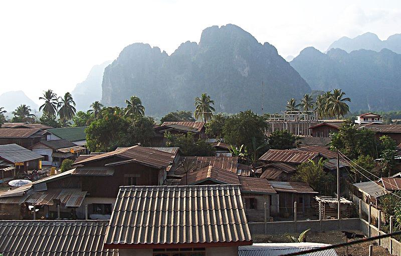 Vang Vieng
Vang Vieng (Lao: ) is a tourism-oriented town in Laos, located in Vientiane Province about four hours bus ride north of the capital. The town lies on the Nam Song river. The most notable feature of the area is the karst hill landscape surrounding the town.[1] Vang Vieng was first settled around 1353 as a staging post between Luang Prabang and Vientiane. Originally named Mouang Song after the body of the deceased King Phra Nha Phao of Phai Naam was seen floating down the river, the town was renamed Vang Vieng during French colonial rule in the 1890s.[2][3] Significant expansion of the town and its infrastructure occurred during the 1964-73 Vietnam War when the US developed an Air Force base and runway that was used by Air America. The airstrip was then called 'Lima site 6'. In more recent times, the town has grown substantially due to the influx of backpackers attracted by the opportunities for adventure tourism in a limestone karst landscape.[1]
 Pakxan
Pakxan, Paksan or Muang Pakxan (Lao ປາກຊັນ) (French: Paksane) is a town in Bolikhamsai Province, in western Laos. It is the capital of Paksan District. The Nam Xan River joins the Mekong River at Paksan on the border with Thailand, opposite Bung Kan.[1][2] Paksan is well connected to the south of Laos by Route 13. The foundation of Paksane date from the late nineteenth century. The region had experienced a Paksane insecurity since the invasion of Annam, 1834, followed by invasions Siamese with the introduction of Siamese suzerainty over Laos in 1836 the country, but especially after 1865, the invasions of "Hos" or "red flags, Chinese gangs from Southern China. These are indeed Hos invasions that began to empty of their populations provinces of Xieng Khouang and Borikhane, but these are the Siamese who complete depopulation by deporting on the right bank of the Mekong much of Phou Eun inhabiting the region to escape the clutches of the invaders.[3]
http://www.wajah.asia/index.php?id=l-a-o-s
![]()
 Previous
![]() LATEST IMAGE
LATEST IMAGE

![]() RANDOM IMAGE
RANDOM IMAGE

![]() WAJAHASIA APP
WAJAHASIA APP
![]() LOGIN
LOGIN
Reset password
Click here to register
Online: 39 Guests, 0 Users
![]() HITCOUNTER
HITCOUNTER